Q: Alaska is home to nearly two-thirds of the land in the entire National Park System—some 54 million acres in all. But only four of our 401 U.S. national park sites lie entirely north of the Arctic Circle. Can you name these four sites?

Parks in the Arctic
See a map of four national park sites in Alaska that are located above the Arctic Circle.
See more ›A: Cape Krusenstern National Monument, Gates of the Arctic National Park and Preserve, Kobuk Valley National Park, and Noatak National Preserve together cover more than 26,000 square miles of protected lands north of the Arctic Circle. This vast, roadless terrain is some of the wildest country in the United States. The Arctic Circle is the latitude at which the sun doesn’t set for a complete day during the summer solstice and doesn’t rise for a complete day during the winter solstice; these parks embody not just the remote and intact ecosystems of Alaska’s Far North, but also the extremes of daylight and darkness that the Land of the Midnight Sun is famous for.
Here’s a brief tour of these untamed destinations at the very top of the map.
Roughly four times larger than Yellowstone National Park, Gates of the Arctic National Park and Preserve is a land of glaciated valleys, scenic rivers, and tundra straddling America’s northernmost mountain range, the Brooks Range. Two large mountains, Mt Boreal and Frigid Crags, stand on either side of the north fork of the Koyukuk River and form the literal “gates” in the park’s name. Though relatively few people visit this wilderness park, it is prime habitat for five of Alaska’s most charismatic wildlife species: grizzly bears, moose, caribou, wolves, and Dall sheep.
Bordering Gates of the Arctic directly to the west, Noatak National Preserve protects the largest untouched mountain-ringed river basin in the country. Most of the Wild and Scenic Noatak River flows within the preserve’s boundaries, providing excellent opportunities to see wildlife, including the Alaska’s largest caribou herd. More than 300,000 caribou in this Western Arctic Herd migrate north each spring and south each fall across the tundra in search of food.
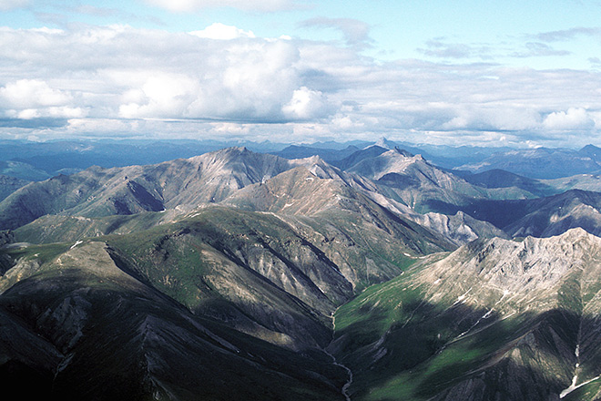 An aerial view of Gates of the Arctic National Park. Photo by U.S. Fish and Wildlife Service.
Just south of Noatak, Kobuk Valley National Park (pictured at top) sits between two mountain ranges, the Baird Mountains to the north and the Waring Mountains to the south. The slow-moving Kobuk River meanders for 61 miles on the southern end of the park, where visitors plan float trips in the warmer months. This park offers another, particularly curious natural feature: enormous sand dunes more than ten stories high, making this region of the Arctic look similar to a desert.
To the west of these three Arctic parks, Cape Krusenstern National Monument encompasses the coastal plains and lagoons that border the Chukchi Sea and Kotzebue Sound, though the park is best known for its archaeological riches. The monument preserves more than 5,000 years’ worth of prehistoric and historic Native Alaskan artifacts from every known period of arctic occupation, including campsites, house ruins, burial grounds, stone tools, pottery, and hunting and whaling implements.
For more on traveling to Alaska, see our story, “Vacationing in the Last Frontier,” and our photo feature on winter in Denali National Park.
About the author
-
 Jennifer Errick Managing Editor of Online Communications
Jennifer co-produces NPCA's podcast, The Secret Lives of Parks, and writes, edits and moderates online content.